2026 El Niño Event: Models Suggest Record-Breaking Strength
Climate models and physical evidence indicate that the 2026 El Niño event could rival the strongest on record, including the massive event from the late 1870s. Professor Paul Roundy explains how tracking warm water progression points to an amplitude potentially higher than any El Niño in the last century. This article examines the science behind these projections and what they mean for global weather patterns.
The climate community is closely monitoring a developing El Niño event that, according to recent model projections, could be among the most powerful in modern history. In a recent interview with FRANCE 24, Professor Paul Roundy, an expert in atmospheric and environmental sciences at the State University of New York at Albany, provided a stark assessment: models and physical arguments based on the movement of warm water suggest that the amplitude of the 2026 El Niño could match or even surpass the strongest events observed in the last century, including the colossal event of the late 1870s. This analysis offers a timely look at the science, the potential global impacts, and what we can expect in the coming months.
Professor Roundy's assessment, shared with FRANCE 24's Sharon Gaffney, hinges on two key pillars: advanced climate modeling and the physical tracking of warm water anomalies. The models, which simulate the complex interactions between ocean and atmosphere, are signaling a potential for extreme warming in the equatorial Pacific. Crucially, these computational projections align with real-world observations of a massive pool of warm water moving eastward across the Pacific basin. This warm water, often described as a "subsurface heat wave," is the fuel that drives El Niño, and its current trajectory and volume are causing concern among scientists.
The Science Behind the Record Predictions
To understand the significance of the 2026 forecast, it is helpful to look at how El Niño is measured. The primary metric is the El Niño 3.4 index, which tracks sea surface temperature anomalies in a specific region of the central Pacific. A strong El Niño typically sees anomalies of +2.0°C or higher.
Historical Context: The 1877-78 Event
The point of reference for such events is the 1877-78 El Niño, one of the most extreme on record. This event triggered widespread droughts, famines, and economic disruption across the globe. Professor Roundy's comments suggest that the 2026 event could "achieve an amplitude similar to the strongest event known back in the late 1870s."
The physical mechanisms behind this potential record lie in the ocean's heat content. El Niño begins when the trade winds weaken, allowing warm water that normally piles up in the western Pacific to slosh eastward. Over the past several months, scientists have observed an unusual buildup of warm water beneath the surface, traveling along the equator. This "warm water volume" is now being released, creating ideal conditions for a powerful warming event.
Potential Global Implications
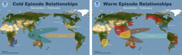
If the 2026 El Niño reaches the predicted amplitude, the consequences for global weather patterns could be profound. Historical analogies and climate modeling both point to a set of well-known impacts:
- Disrupted Rainfall: El Niño typically brings increased rainfall and flooding to the southern United States and parts of South America, while causing severe drought in Southeast Asia, Australia, and parts of Africa. A super El Niño would amplify these extremes.
- Global Temperature Spike: El Niño releases immense amounts of heat from the Pacific into the atmosphere. This often leads to record-breaking global average temperatures. A very strong event in 2026 could push global temperatures well above previous records, potentially exceeding 1.5°C of warming above pre-industrial levels.
- Ecosystem Stress: Marine ecosystems, particularly coral reefs, are highly vulnerable to the warm waters associated with El Niño. A massive event could cause widespread coral bleaching and disrupt fisheries.
- Agricultural Vulnerability: The disruption of monsoon patterns in Asia and the failure of rains in Australia could lead to reduced crop yields, impacting global food security.

Conclusions and Next Steps
While the projections from Professor Roundy are alarming, it is important to note that climate models are not certainties. The evolution of El Niño remains a complex system with inherent unpredictability. However, the convergence of model data and physical evidence is a strong signal that the world should prepare for a potentially historic climate event. Scientists will continue to monitor key indicators, including sea surface temperatures, trade wind strength, and subsurface ocean heat content. The coming weeks will be critical for verifying if the 2026 El Niño indeed sets a new benchmark for intensity.
For policymakers, emergency managers, and citizens in vulnerable regions, this forecast serves as a powerful reminder of the need for robust disaster preparedness. The risk of extreme weather, from floods to droughts, is elevated. The scientific community, as highlighted by Professor Roundy's work, is providing the best possible early warning. The question now is how societies will respond to the warning before the full force of the event arrives. Stay informed through reliable sources like FRANCE 24 for the latest updates on this developing story.