Magnitude 7.4 Earthquake Strikes Off Indonesia, Killing One and Triggering Tsunami Warnings
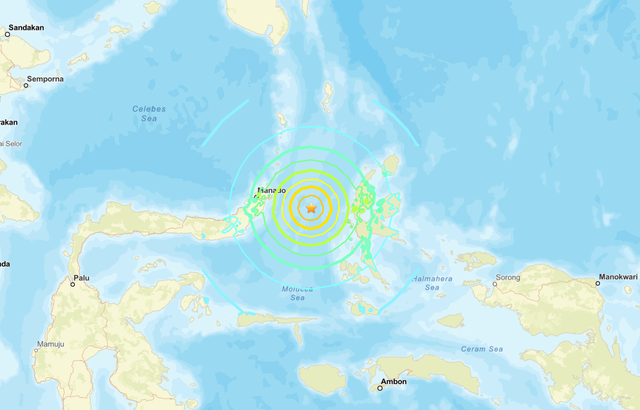
A powerful 7.4-magnitude earthquake struck the Molucca Sea between the Indonesian islands of Manado and Ternate early Thursday, resulting in at least one fatality and prompting tsunami warnings across the region. The quake, which occurred at a depth of 35 kilometers, caused significant shaking felt across North Sulawesi and North Maluku provinces, with residents describing it as one of the strongest tremors in recent years. While tsunami alerts have been lifted, authorities warn of potential aftershocks following the initial seismic event.
A powerful 7.4-magnitude earthquake struck the Molucca Sea off Indonesia's Ternate island early Thursday, resulting in at least one fatality and prompting tsunami warnings across the region. The seismic event, which occurred at 06:48 local time (22:48 GMT) at a depth of 35 kilometers, has highlighted the ongoing vulnerability of Indonesia's archipelago to significant geological activity. This article examines the immediate impacts of the earthquake, the response from authorities and residents, and the broader context of seismic risk in one of the world's most geologically active regions.
Earthquake Details and Immediate Impact
The earthquake's epicenter was located roughly midway between the cities of Manado on Sulawesi island and Ternate in North Maluku province, according to geological monitoring agencies. The 7.4 magnitude tremor was followed by at least two significant aftershocks measuring 5.5 and 5.2 on the Richter scale, with authorities warning that additional aftershocks could occur in the coming days. The depth of 35 kilometers placed it within the category of shallow earthquakes, which typically cause more intense surface shaking than deeper seismic events.
Indonesia's national news agency Antara reported that a 70-year-old woman in North Sulawesi died after being crushed by building debris, marking the first confirmed fatality from the earthquake. Another individual suffered a broken leg after jumping from a building during the intense shaking. The national geological agency confirmed "damage to buildings and injuries" approximately one hour after the initial tremor, though detailed assessments of structural damage across affected areas were still underway.

Tsunami Warnings and Regional Response
The Hawaii-based Pacific Tsunami Warning Center initially issued alerts for potential tsunami waves less than 0.3 meters (1 foot) along the coasts of multiple countries and territories, including Guam, Japan, Malaysia, Papua New Guinea, the Philippines, and Taiwan. These warnings were based on the earthquake's magnitude, depth, and location in a seismically active subduction zone where tectonic plates converge. Indonesian authorities activated their own tsunami warning systems for coastal communities near the epicenter.
After approximately two hours of monitoring sea level data from buoys and coastal stations, tsunami warnings were lifted across the region when no significant wave activity was detected. This decision followed established protocols for tsunami alert management, which balance the need for public safety with the economic and social disruption caused by unnecessary evacuations. The relatively quick lifting of warnings suggests that the earthquake's specific characteristics did not generate the substantial vertical seafloor displacement typically required for dangerous tsunami generation.
Resident Experiences and Local Response
Residents across affected areas reported intense shaking that lasted for several seconds, with many describing it as one of the strongest earthquakes they had experienced in recent years. Journalist Isvara Safitri, who lives in central Manado, told BBC Indonesian that furniture in her room shook violently and the experience left her feeling dizzy. "It was really strong... My head even felt dizzy," she reported, adding that the earthquake "feels like the strongest" she's experienced over the past six years.
In Bitung, a city on the northeastern coast of Sulawesi, resident Yayuk Oktiani was at a local market when "everything started shaking." She described scenes of panic as several stores experienced power outages and people fled the area. Oktiani immediately headed to her child's school, located near the coast, where she found "chaotic" conditions as teachers instructed parents to take their children home despite having just arrived for the day. The rapid response from educational institutions highlights the ingrained earthquake preparedness protocols in this seismically active region.

Emergency Response and Medical Evacuations
Medical facilities in affected areas implemented emergency protocols following the earthquake. At Siloam Hospital in Manado, 69-year-old patient Admini described the frantic evacuation efforts as staff and patients were moved to safer locations. "We were sitting there drinking tea... [Initially we] didn't realise it was an earthquake. And then we heard a child scream, 'Come down, hurry up,'" she recalled. Medical personnel quickly established makeshift treatment areas outside the hospital building and inside vehicles to continue providing care while ensuring safety from potential structural damage.
Search and rescue teams were deployed to assess damage and assist affected communities. Footage from Manado showed residents and officials navigating rubble at a sports complex where large pieces of furniture had been thrown to the ground and metallic structures were bent out of shape. These visual records provide early documentation of the earthquake's impact on infrastructure and will inform ongoing damage assessment efforts by local and national authorities.
Geological Context and Seismic Risk
Indonesia's location along the Pacific Ring of Fire makes it particularly vulnerable to earthquakes and volcanic activity. The country sits at the convergence of several major tectonic plates, including the Australian, Eurasian, Pacific, and Philippine Sea plates. The Molucca Sea region where Thursday's earthquake occurred is part of a complex collision zone where multiple plates interact, creating frequent seismic activity. While the region regularly experiences tremors, residents noted that this event was unusually strong compared to recent seismic activity.
The depth of 35 kilometers places this earthquake within the upper portion of the Earth's crust, where seismic waves travel more efficiently to the surface, amplifying ground shaking. Shallow earthquakes of this magnitude typically cause more significant damage than deeper events of similar strength, as the energy release occurs closer to populated areas and infrastructure. Indonesia's geological monitoring agencies maintain extensive networks of seismometers to detect and analyze such events, providing critical data for early warning systems and risk assessment.
Conclusion and Preparedness Considerations
The magnitude 7.4 earthquake off Indonesia's Ternate island serves as a reminder of the persistent seismic risks facing communities throughout the archipelago. While the immediate tsunami threat has passed and casualty numbers remain relatively low, the event underscores the importance of robust early warning systems, public education about earthquake safety, and resilient infrastructure design. As authorities continue to assess damage and monitor for aftershocks, the experiences shared by residents highlight both the effectiveness of existing preparedness measures and areas where response capabilities could be strengthened.
For communities living in seismically active regions, this earthquake reinforces the need for regular drills, secure building practices, and clear evacuation plans. The relatively coordinated response from medical facilities, schools, and emergency services demonstrates progress in disaster management, while the structural damage reported indicates ongoing vulnerabilities in some buildings. As Indonesia continues to develop its disaster risk reduction strategies, events like Thursday's earthquake provide valuable lessons for enhancing resilience against future seismic events.