Unusual Jet Stream Triggers Severe Middle East Thunderstorms and Flooding
An abnormally strong jet stream has unleashed a series of severe thunderstorms across the Middle East, bringing unprecedented rainfall and flooding to typically arid regions like the UAE and Saudi Arabia. The weather pattern, which delivered up to 150mm of rain in just days, highlights the increasing intensity of extreme weather events linked to climate change. This article examines the meteorological causes, regional impacts, and the broader implications of these unusual storms.
An unusual and powerful weather pattern has recently unleashed severe thunderstorms across parts of the Middle East, bringing unprecedented rainfall and flooding to typically arid desert regions. Countries including the United Arab Emirates (UAE) and Saudi Arabia experienced a deluge caused by an abnormally strong jet stream, a phenomenon more commonly associated with temperate climates. This event underscores the growing volatility of global weather systems and their increasing impact on regions historically defined by stable, dry conditions.
The Meteorological Trigger: An Abnormal Jet Stream
The primary driver of this extreme weather event was an unusually potent jet stream. This high-altitude, fast-flowing air current helped develop a deep area of low pressure north of Saudi Arabia. According to analysis from The Guardian's weather tracker, this low-pressure system acted as a pump, drawing moist tropical air northwards from the Indian Ocean. When this warm, moisture-laden air collided with the atmospheric dynamics set up by the jet stream, it triggered intense and sustained thunderstorms across the Arabian Peninsula.
Regional Impacts and Unprecedented Rainfall
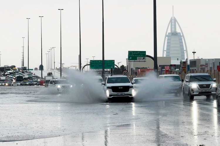
The impacts across the region were severe and multifaceted. The Arabian Peninsula, which typically receives annual rainfall totals between 60-100mm, saw some areas receive up to 150mm in just a few days. A weather station on Jebel Yanas in the northern UAE recorded a staggering 244mm of rainfall. The storms were not isolated to a single day; a more organized line of thunderstorms crossed the UAE on Thursday evening, hitting densely populated urban centers like Dubai and Abu Dhabi. These storms brought gusts of up to 80mph, large hail, and intense lightning, leading to widespread flooding that disrupted daily life and infrastructure.

Other nations were also heavily affected. In Oman, hailstones reportedly as large as tennis balls fell during the storms, accompanied by torrential rain. Doha, the capital of Qatar, experienced significant flooding. While thunderstorms do occur in the region, the multi-day, widespread nature of this deluge is more characteristic of spring and summer storm patterns in the central United States or Europe, making it a highly unusual event for the Middle East.
Broader Context and Climate Connections
This extreme weather event fits into a broader global pattern where storms are delivering more intense rainfall as the climate warms. A warmer atmosphere holds more moisture, which can be released in shorter, more violent bursts. The event in the Middle East serves as a stark reminder that climate change is altering historical weather norms, making extreme events more frequent and severe even in regions not traditionally prone to them. The societal and economic costs of such events, particularly in rapidly developing urban areas like Dubai, are substantial and highlight the urgent need for climate-resilient infrastructure.
Shifting Weather Patterns: The Mediterranean in Focus
As the immediate situation in the Middle East stabilizes, meteorological attention is shifting westward to the Mediterranean. Forecasts indicate a developing low-pressure system southeast of Italy is expected to bring heavy rain and thunderstorms to Greece, Turkey, and other parts of southeastern Europe. Rainfall totals could reach 100mm in some areas, raising renewed flood risks. Furthermore, parts of northern Africa, including Libya—which was recently affected by Storm Samuel—are bracing for potentially damaging gusts of 60-80mph from the same system.

Conclusion: A New Normal for Extreme Weather
The severe thunderstorms that drenched the Middle East represent more than an isolated anomaly; they are a signal of shifting atmospheric patterns in a warming world. The role of the jet stream in triggering such extreme events in arid regions underscores the interconnectedness of global climate systems. As these patterns evolve, regions worldwide must enhance their preparedness and adaptation strategies. Understanding and monitoring these complex meteorological drivers, as detailed in reports from sources like The Guardian, is crucial for mitigating future risks and building resilience against the growing threat of climate-induced weather extremes.