The Rise of Category 6: How Deep Ocean Hot Spots Are Fueling Unprecedented Hurricanes
Climate change is supercharging the world's most powerful storms by creating vast, deep ocean hot spots that provide unprecedented energy to hurricanes and typhoons. New research reveals these regions, particularly near the Philippines and the Caribbean, are expanding as warming penetrates far below the ocean surface. This has led to a dramatic increase in storms powerful enough to exceed the current Category 5 classification, with over half of these extreme events occurring in just the past decade. Scientists are now advocating for a new 'Category 6' classification to improve public awareness and disaster preparedness for these climate-fueled super-storms.
The traditional five-category scale for classifying hurricanes and typhoons is being challenged by a new climate reality. As ocean waters warm not just at the surface but deep below, specific regions of the world's oceans are transforming into powerful engines for storm intensification. These expanding 'hot spots' are making the strongest tropical cyclones more likely, more intense, and more dangerous than ever before, prompting scientists to call for a fundamental rethink of how we categorize and prepare for these extreme weather events.
The Science Behind Deep Ocean Hot Spots
The key driver of this new era of super-storms lies not in surface temperature alone, but in the depth of the ocean's warmth. In most parts of the ocean, a powerful storm churns up cooler water from the depths, which acts as a natural brake on its intensity. However, in specific hot spot regions identified by researchers, warm water extends hundreds of meters below the surface. This deep reservoir of heat means storms can continue to draw energy without encountering the cooling effect that typically limits their strength. According to research presented at the American Geophysical Union's 2025 Annual Meeting, these conditions create a 'necessary but not sufficient' environment for the development of the most extreme cyclones.
Mapping the Expansion of Danger Zones
These storm-fueling hot spots are not static; they are growing. The primary regions of concern are in the Western Pacific, east of the Philippines and Borneo, and in the North Atlantic, near and east of Cuba, Hispaniola, and Florida. Analysis shows the North Atlantic hot spot has spread eastward beyond South America and westward into the Gulf of Mexico, while the Western Pacific zone has also increased in size. This geographical expansion, driven significantly by human-caused climate change, is putting more coastal communities at risk. Researchers estimate that climate change may account for 60-70% of the growth of these deep warm-water regions.

The Case for a Category 6 Classification
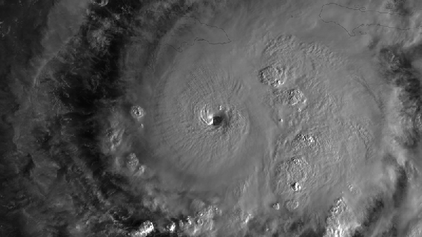
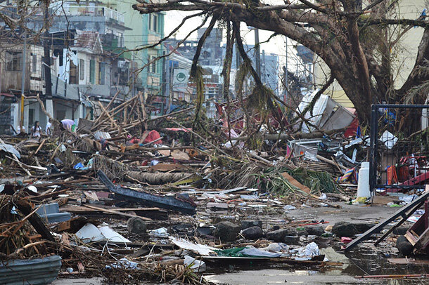
The current Saffir-Simpson Hurricane Wind Scale caps its highest designation, Category 5, at winds of 137 knots (157 mph) or greater. This broad grouping now encompasses storms of vastly different destructive potential. Scientists, including Professor I-I Lin of National Taiwan University, propose defining a Category 6 for storms with sustained winds exceeding 160 knots (184 mph). This adjustment would align with the scale's logic, as other categories span roughly 20-knot ranges. The call for a new category gained urgency after events like 2013's Typhoon Haiyan, which devastated the Philippines with winds far beyond the Category 5 threshold.
The Growing Frequency of Off-the-Charts Storms
The data reveals a clear and alarming trend. A review of tropical cyclone records from the past four decades identified 18 storms that would qualify as Category 6 under the proposed definition. Strikingly, more than half of these—10 storms—occurred in the most recent decade (2013-2023), compared to 8 in the prior thirty-year period (1982-2011). This acceleration includes legendary storms like Hurricane Patricia (2015), which holds the record as the strongest tropical cyclone ever observed with winds up to 185 knots, and Hurricane Wilma (2005), the most intense hurricane ever recorded in the Atlantic basin.
Implications for Preparedness and Policy
Formally recognizing a Category 6 is not merely an academic exercise; it is a crucial step in public safety and disaster planning. A higher category would provide clearer, more urgent communication to the public about the unprecedented danger posed by these climate-enhanced storms. It would signal to governments and communities in vulnerable regions—many of which are highly populated—that their infrastructure and evacuation plans must account for a new tier of intensity. As these deep ocean hot spots continue to expand, improving risk awareness and resilience is paramount.
The evidence is clear: the ocean's capacity to breed catastrophic storms is evolving. The expansion of deep warm-water hot spots is a direct consequence of a warming climate, and it is rewriting the rules of hurricane and typhoon intensity. Acknowledging this new reality through updated classification systems is an essential first step in adapting to a future where the most powerful storms on Earth are becoming frighteningly common.